Historical Maps of Ithaca and Tompkins County

Cover Image:
Historical Maps of Ithaca and Tompkins County
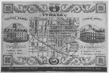
Woodcut Map of Ithaca, circa 1836 - Image Source

Collection Facts

Extent:
11
Dates of Original:
1836 - 1889

Historical Context

Tompkins County is in the west central part of New York State, south of Syracuse and northwest of Binghamton. It is usually geographically grouped with the Finger Lakes region, but some locals consider themselves to be part of Central New York or the Southern Tier. The city of Ithaca is the county seat. The county is also home to Cornell University, Ithaca College and Tompkins Cortland Community College.

Scope of Collection

The original collection contains three maps of the city of Ithaca: An 1872 map of the incorporated city which includes the names of property owners and ward boundaries, an 1889 map of the city produced from actual land surveys and records, and an 1836 woodcut map of the city with ornate borders and corner rosettes which features two former hotels in the downtown area.

In 2022, a collection of eight Clock System maps were added to the digital collection.  These Clock System maps were an innovative way to display locations of farmhouses in rural countryside.  A directory was built into each map to help identify locations.

Browse similar collections

Collection Type: