Following the disastrous floods of 1935, 1946, and 1956, many areas of New York State built infrastructure designed to mitigate future flooding. Much of the money came from government initiatives to revitalize the economy, such as the New Deal.
These programs and flood control plans funded the dike system around Cattaraugus County, Mt. Morris Dam in Livingston, and Kinzua Dam. The dams in Arkport and Almond were built by the US Army Corps of Engineers in the 1930s and 1940s, and improvements were made to flood barriers in Avoca and Addison as well.
Schuyler County had been devastated by the 1935 flood, so throughout the 1940s, officials in Montour Falls successfully petitioned the New York State Flood Control Commission for funds to reroute the local creeks.
Ithaca’s flood prevention project was finished in 1969. Thanks to these events, Tompkins County and Schuyler County were much less severely impacted by Agnes than their neighboring counties.
The Hurricane Agnes flood was more destructive than any that had come before it, but it certainly was not the last to assail the region. Recent floods have left their mark on current residents of New York State. Despite all efforts to improve flood preparedness in the region, as of 2021 the Southern Tier remained the region with the highest risk of flooding in the state.

Steuben flooding state of emergency remains, Addison residents cleared to go home. The Leader (Corning, NY). August 19, 2021. Courtesy of The Leader.
Flash flooding continues to plague the Southern Tier.
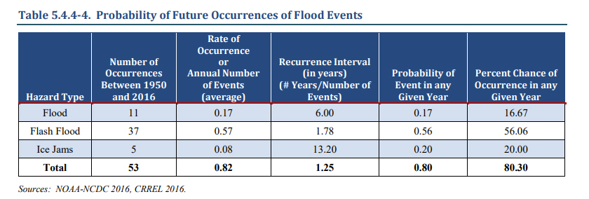
Probability of Future Occurrences of Flood Events. Courtesy of
This 2018 Hazard Mitigation Plan was prepared and updated by Allegany County as part of the Disaster Mitigation Plan Act of 2000. This report analyzes risks and hazards throughout the county.
As shown in this table from the report, Allegany County had 53 flood events between 1950 and 2015, despite the flood control measures taken by federal and state programs. Flash floods continue to be an issue for communities along the many creeks and tributaries.